Welcome!
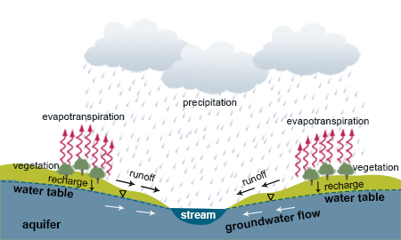
DWEE has developed three computer simulations to illustrate the interaction of surface water and groundwater. To begin, explore how changing the elevation of the water tableThe water table is the upper level of the underground area in which the soil and rocks are saturated with water. affects this interaction.
Water Table
The purpose of this simulation is to illustrate the interaction between surface water and groundwater, focusing on how the relative position of the water table and stream levels affects the direction of flow and rate of interaction between the stream and the aquiferAn aquifer is the area saturated with water beneath the water table. (i.e., whether a stream is a gainingA stream is gaining in reaches where water flows from the aquifer towards the stream. or losing streamA stream is losing in reaches where water flows from a stream towards the aquifer.).


Indicator
Use the slider bar to adjust the water tableThe water table is the upper level of the underground area in which the soil and rocks are saturated with water. elevation.
This simulation shows basic surface water and groundwater interactions. When the water table is above the top of the stream, the aquiferAn aquifer is the area saturated with water beneath the water table. replenishes the stream as baseflowBaseflow is the portion of streamflow that results in seepage of water from the aquifer. (i.e., gaining stream); when the water table is below the top of stream, the water flows out of the stream to the aquifer (i.e., losing stream). When they are at equilibrium, there is flow between the aquifer and the stream, but no net loss or gain to the stream.
Use the slider bar to adjust the intensity of rain.
This simulation shows that heavier precipitation contributes to higher runoffRunoff is water that drains across the surface of an area of land. and a slight increase in groundwater rechargeRecharge is a process where water moves downward into groundwater., but lighter precipitation is associated with lower runoff and recharge in a precipitation event. The streamflow increase after a rain event is primarily due to surface runoff. The hydrographThis hydrograph is a graph of how precipitation and streamflow change over time. to the right shows the streamflow response to differing levels of precipitation. Hover over the hydrograph to learn how to read it.
Click the slider bar to adjust the soil texture.
This simulation shows how soil texture, which corresponds with pore space, affect the flow of water through soil. Coarser soil with larger pore spaces allows water to move more easily through the ground. Precipitation infiltrates faster and there is more interaction between the groundwater and the stream. Coarse soil texture means more rechargeRecharge is a process where water moves downward into groundwater. and baseflowBaseflow is the portion of streamflow that results in seepage of water from the aquifer., whereas fine soil texture means less. The hydrographThis hydrograph is a graph of how precipitation and streamflow change over time. to the right shows the streamflow response to a precipitation event given different soil textures. Hover over the hydrograph to learn how to read it.
Streamflow (cfs)
Precipitation (inches)
Elapsed Time (hours)
Precipitation
Streamflow
Adjust the water table elevation using this slider or by clicking on the slider's labels.
Watch how the aquifer depth, streamflow, and the direction of groundwater flow change as you adjust the water table elevation.