Registered Groundwater Wells Database
Legend and Notes:
Use Code  Water Use
 ----     ---------
   A          Aquaculture
   C          Commercial/Industrial
   D          Domestic
   E          Pit - Irrigation
   G          Ground Heat Exchanger well - Closed Loop Heat Pump well
   H          Heat Pump well - Open Loop Heat Pump Well
   I          Irrigation
   J          Injection
   L          Observation (Ground Water Levels)
   O          Other - Lake Supply, Fountain, Geothermal, Wildlife, Wetlands,
              Recreation, Plant & Lagoon, Sprinkler, Test,Vapor Monitoring
   P          Public Water Supply with Spacing Protection
   Q          Monitoring (Ground Water Quality)
   R          Recovery
   S          Livestock
   T          Geothermal
   U          Public Water Supply without Spacing Protection
   W          Dewatering (Over 90 Days)
Car Connectted to pump into a common carrier
DEQ Part of a DEQ site plan for spill or underground storage
Mon Monitoring Wells Part of a single site
PRO Single Project
Registration Number (example G81537A) Prefix of well registration number ('A' or 'G')
  Well registration number (6 digits) (#81537 in above example)
        This number is assigned by Nebraska Department of Natural Resources.
  Suffix of well registration number (A-Z, AA-ZZ) (A in above example)
      Status Status of the well
        A       Active
        I       Inactive
        S       Suspense (Replacement well, original well not yet decommissioned)
        U       Unregistered Decommissioned
        X       Decommissioned
        Z       Inactive Suspense (Pump Not installed, Replacement well,
                 original well not yet decommissioned
Times Replace Number of times well has been replaced
Well Location refers to township (North), range (East or West), section and sub section
|
Sub Section Examples: |
|
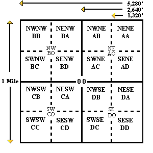
See “Map It” from well location. Wells are mapped in following order:
        1.   GPS
        2.   Footage
        3.   Legal description location.  If no GPS or footage is available, well will be mapped
		in center of legal description provided.
Filing Date (Registration Date) is the registration filing date
Completion Date is the date when the well completed construction
Decommissioned Date is the year and month when the well was decommissioned in format yy/mm
Gallons/Min is the pumping rate in gallons per minute
Well Depth is the total depth of the well in feet
Static Water Level and Pumping water level are in feet
Pump Col Diameter (Pump Column Diameter) is the column size in inches
Pump Depth is the depth to the pump in feet
Footage is the number of feet from section line to well location
Permit Number is the management area permit code.
This number is assigned
 by the individual Natural Resources Districts.